The High Island Reservoir East Dam Hike: Hong Kong's Hexagonal Rock Columns
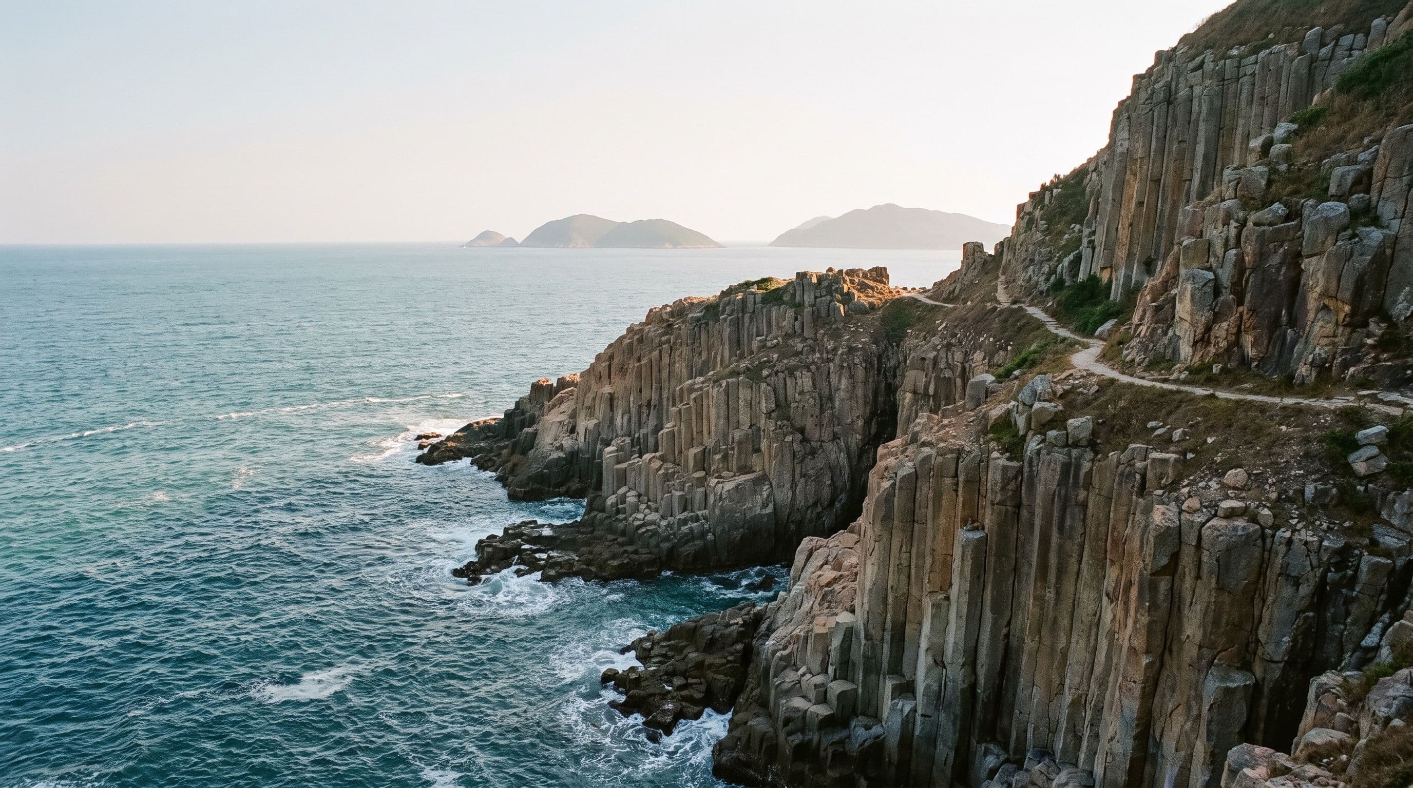
The High Island Reservoir East Dam hike is the easiest way in Hong Kong to stand next to rock that looks poured rather than formed. A short trail along the East Dam in Sai Kung leads to cliffs built entirely from hexagonal stone columns, part of a formation that reaches up to 100 metres high on some of the geopark's islands and sea cliffs. You don't need to be a geology buff to find it striking, and you don't need to be a serious hiker to reach it.
What makes this hike worth it
The columns here aren't a curiosity, they're one of the reasons Hong Kong has a UNESCO Global Geopark. The rock formation was named one of the First 100 IUGS Geological Heritage Sites in October 2022, putting it alongside some of the most significant geological sites on the planet. Most of the world's hexagonal rock columns, like the Giant's Causeway in Northern Ireland, are dark basalt. The East Dam's columns are pale, silica-rich rhyolite, a type of lava that almost never cools into this shape. Seeing them up close, stacked and buckled along the cliff edge, is the actual draw, not just the view. If you want an easy outing before tackling something steeper like Lion Rock or a 4am start for Lantau Peak at sunrise, this is a gentle place to start.
The route: distance, time and difficulty
The walk to see the columns follows the High Island Geo Trail's Po Pin Chau Section. It starts near the High Island Reservoir Monument on the East Dam and runs out to the Po Pin Chau Viewing Platform and back.
- Distance: about 2km round trip
- Elevation: over 200m of climbing in total
- Time: roughly 2 hours there and back, including stops
The path itself is well maintained with interpretation panels along the way, and it's walkable by hikers of most fitness levels, but the elevation means it's more than a flat stroll. Along the route you'll pass buckled, S-shaped rock columns cut through by a dark volcanic dyke, one of the clearest examples of what happens when a geological fault squeezes still-cooling rock. The trail ends at a platform looking across to Po Pin Chau, a narrow rock islet that broke away from the cliff after centuries of wave erosion, plus a sea cave carved into the same columnar rock. It's a different experience to the exposed scrambling on the Sharp Peak hike further into the same Sai Kung East Country Park, no ridge-walking required.
The hexagonal rock columns, explained
About 140 million years ago, a supervolcano erupted in what's now the Sai Kung area. When its magma chamber emptied out, the ground above it collapsed into a huge caldera roughly 20km across. Fresh volcanic material pooled inside that caldera and cooled slowly in a sealed, stable environment, cracking into the tight hexagonal pattern you see today as it contracted. The result: columns averaging 1.2m across, with the largest measuring 3m, some of them over 400m thick and exposed up to 100m high on nearby cliffs. A quarry dug into the East Dam cliffs in 1971, during construction of the reservoir itself, is what first exposed this rock face to view.
How to get to the East Dam
Getting there takes some planning, because two of the three routes only run on weekends and public holidays.
- Bus + green minibus (weekends/holidays only): take bus route 94 from Sai Kung town centre, 96R from Diamond Hill MTR Station, or 289R from Sha Tin town centre to Pak Tam Chung, then Green Minibus route 9A on to the East Dam. All three of 96R, 289R and GMB 9A run Saturdays, Sundays and public holidays only.
- Ferry + hike (weekends/holidays only): take the kaito ferry from Berth No. 3 of Sai Kung Public Pier (adult or child HK$65 single trip) to High Island, then walk from Leung Shuen Wan Pier via Sai Kung Man Yee Road to the East Dam, about 4km and an hour on foot.
- Taxi (every day): a taxi from Sai Kung town centre or Pak Tam Chung to the East Dam is the only option that isn't restricted to weekends.
Before you go
Hong Kong's Geopark authority has trialled requiring hikers to book a slot in advance through Klook for the Po Pin Chau Section specifically, to manage crowding on busy weekends. It isn't a permanent rule, so check the Hong Kong Geopark website or the Klook listing for this trail before you set out, in case a booking window happens to be running when you visit. Bring your own water and sun protection either way: there's little shade along the dam, and the final stretch to the viewing platform has no shelter at all. Pak Tam Chung, the usual transfer point, is also the gateway for several other Sai Kung day trips, so it's worth checking what else is nearby before you commit to a single bus back.
Quick answers
How long is the High Island Reservoir East Dam hike? About 2km round trip and roughly 2 hours including stops, with over 200m of total elevation gain.
Is the East Dam hike hard? No technical difficulty, but it isn't flat either. Most reasonably fit hikers manage it comfortably.
Can I reach the East Dam by public transport every day of the week? Not quite. The minibus, the connecting buses, and the ferry all run weekends and public holidays only. A taxi is the only way in on a weekday.
Do I need to book a ticket for the East Dam hike? Not always. The Geopark has periodically required advance booking via Klook for the Po Pin Chau Section on its busiest weekends, so check before you go.